The United Nations Educational, Scientific and Cultural Organisation (UNESCO) recognises WHS through the Convention Concerning the Protection of the World Cultural and Natural Heritage (1972), more commonly known as the World Heritage Convention and which has been ratified by 194 member states.
World Heritage status is not automatically bestowed on a property by the States Party Government or UNESCO. All World Heritage Sites must have a clear case for Outstanding Universal Value to be inscribed onto the World Heritage List.
The normal route to inscription in the UK is for a local partnership to come together around a common belief that a place or area has the potential to be a World Heritage Site, and then work with the Government and its agencies to gain a place on the UK’s ‘Tentative List for Nominations’. They must then produce a Technical Evaluation of the Site’s potential OUV for approval by the UK Government. The Partnership is then able to develop and submit a Nomination to UNESCO, whose World Heritage Committee makes the decisions at their annual meetings.
Why does The Flow Country deserve World Heritage status?
The Flow Country World Heritage Site straddles Caithness and Sutherland, lying at the heart of one of the largest and most-intact areas of blanket bog anywhere in the world.
It is the quality and extent of the blanket bog habitat that gives The Flow Country its outstanding universal value and justifies its place on the world heritage site list. In making this argument to UNESCO, we are saying that The Flow Country is the best example of this type of habitat anywhere in the world.
In addition to being a stronghold for a globally rare type of peatland and the associated vital local ecosystem services, The Flow Country is also a place of work and leisure for locals and visitors to the far north.
Special qualities:
Blanket bog is a specific and globally rare form of peatland, confined to the oceanic margins of the cool temperate zones of the northern and southern hemispheres. It is typically treeless over much of its range, covering undulating topography like a blanket. The range of climatic conditions and landforms found across Caithness and Sutherland together give rise to distinctive forms of blanket bog habitat characterised by varied vegetation assemblages and surface patterns.
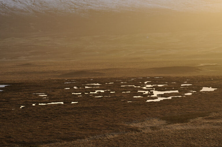
In The Flow Country the variety of characteristic surface patterning, including numerous groups of pools and pool systems, of various shapes and sizes, “glitter like jewels in the landscape” when seen from above or higher ground (Lindsay et al., 1988). These occur in intricate patchworks with alternating hummocks of bog moss (Sphagnum spp.) and lichens, and wet hollows.
Together with its intimately associated areas of mountains, heaths, fens and open water, this area is of international importance for its habitat and the range of wildlife it supports, including a variety of specialist plants, globally unique assemblages of birds, and a range of other major species groups (mammals, fish, insects, microbes).
The biodiversity found across The Flow Country reflects the internationally rare and important assemblage of habitats, flora and fauna. It is home to a bird assemblage not seen anywhere else in the world and supports over 10% of the global Sphagnum bog moss flora.
As well as the quality of its habitat and representative biodiversity, the Site is also significant for carbon sequestration and storage, climate regulation, oxygen production, water regulation and water quality. Carbon sequestration, and subsequent storage, has occurred as an integral part of the process of blanket bog formation for approximately the last 9000 years and continues today.
World Heritage Site Boundary
The wider Flow Country is an area of blanket bog some 400,000 ha across Caithness and Sutherland. The Flow Country World Heritage Site covers just under half of the full expanse of blanket bog, comprising seven discrete but adjacent areas. The areas within the boundary have been selected for the high quality of the peatland and the continuity of the habitat. A map of the World Heritage Site boundaries can be viewed below.
Documentation
World Heritage Site boundary map PDF
World Heritage Site boundary GIS shapefiles
This dataset is available under the terms of the UK Open Government Licence (https://www.nationalarchives.gov.uk/doc/open-government-licence/version/3/).
The following attribution statement must be used to acknowledge the source of the information:
Copyright Highland Council. Contains Ordnance Survey data © Crown copyright and database right [2023].
World Heritage Site Draft Management Plan
Please note, this is the draft management plan for the proposed World Heritage Site, this will be updated to reflect the recent inscription.


