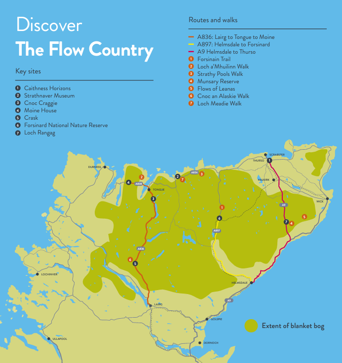
Experience the magic of the Flows with one of the many walks throughout the Flow Country. Marvel at the intricate pool systems, climb the hills and navigate the Dubh Lochans.


The Forsinain Trail (6.5km)
The Forsinain Trail explores the landscapes that make the Flow Country so special, taking you through farmland, open hill ground, and former plantation. The farmland is an important feeding ground for birds like golden plover, dunlin and curlew. The trail also takes you past an area of dubh-lochain and a small loch where red-throated divers sometimes breed.
To get there: Travelling north up the A897, the starting point is 4 miles north of Forsinard. Park at the RSPB Scotland car park opposite the concrete bridge.
Start point co-ordinates: NC 903 485
Loch a’Mhuilinn Walk (1.6km)
A short walk with two branches, both leading to the loch. Along the walk you will be able to see areas where people have cut peat in the past for household fuel.
To get there: Turn off the junction on the A838 signposted to Talmine and Melness (on the right if you are heading west). Head along this road until you see a small car park on the left, close to a turn off to Melness House.
Start point co-ordinates: NC 579 607
Strathy Pools Walk (3.2km)
A track leads out to the phone mast and an extensive panoramic view over the North Sutherland part of the Flow Country.
To get there: From Strathy, head west on the A836 and park in the first marked parking space just outside the village on the left.
Start point co-ordinates: NC 825 652
Munsary Reserve (9.5km)
The reserve at Munsary is managed by Plantlife Scotland. There is a 6-mile return walk along a farm track, along which you can see common heathland and wetland plant species.
To get there: Heading North on the A9 beyond North Rangag, turn right at the Achavanich onto the road signed to Lybster. About 820m from the junction, turn left onto a track, cross a cattle grid and park by the sign on the right.
Start point co-ordinates: ND 186 423
Flows of Leanas (Camster Wind Farm) (6km)
A circular walking and bike route, with good views of peatland in different stages of restoration.
To get there: From Latheron take the A99 north towards Wick. Shortly after Lybster take a left turn signposted to the Grey Cairns of Camster. After the Cairns (which are on the left hand side as you head north) you will see the wind farm and a track turning off to the right.
Start point co-ordinates: ND 257 461

Looking for more?
Other walks in the area can be found on:
Walk Highlands
Highlife Highland
Highland Council
Visit Scotland also has a website with suggested walks in the region, walks are subdivided into categories of easy, moderate, strenuous or Munros.
Please remember to follow the Scottish Outdoor Access Code to protect the environment and respect local communities.
